
Georeferenced Maps
Georeferenced Maps
Georeferenced maps are linked to GPS coordinates on the earth’s surface. This enables users to see their location and direction on image based maps. They are frequently used by state and national parks to allow hikers to see their location on trail maps.
Smartphone Instructions
On your phone, download the Avenza app (Android, iOS). This app is frequently used by state and national parks and is well respected.
Click “Copy Text” for the desired map. Or, manually copy the “http://…” path above the button.
Import the Map into Avenza
Open the Avenza app and press the + sign.
Choose “Import Maps”.
SCROLL TO THE BOTTOM, select “From the Web.”
Paste the Map Text that you copied and click “Go.”
You should now see the map and your location.
North Sand Lake Bathymetric Map
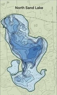
Map Link: North Sand Lake Bathymetric Map
https://www.northsandlake.com/s/NSL-Bathy-2025-10-06-0906.TIFF
Voyager Village 2025 Trail Map

Map Link: Voyager Village 2025 Trail Map
https://www.northsandlake.com/s/Voyager-Village-Trails-2025-Georeferenced.tiff